
Upper Dosewallips River
Class IV+, 82fpm, ~100 cfs
November 11, 2001
Ben, Josh
Author: Josh Hummel
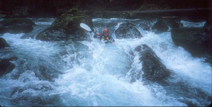
Ben enters The Maze a short ways below the put-in.
Photographer: Josh
Driving along the Hood Canal and through the Olympics was beautiful. Ben had wanted to check out several rivers in the Olympics for the last two weeks. A couple of ski trips and the Tilton had put the Olympics on hold. Saturday we didn’t go because Troy wasn’t up to the challenge. He still couldn’t roll. Jason was sick and unable to do anything for the last couple of days. He even missed some time at work. So yet again it was up to Ben and I to do all the dirty work.
We were going to clean it up on the Dosewallips. A Class IV+ river just south of Brinnon on the Olympic Peninsula. At the Dosewallips State Park we left the road bike I had brought along for our shuttle. Ben and I stashed it behind a large tree. I put some brush over it and hoped it would be there when we finished running the river. As for the water volume? We took a look at it and it was low. We hoped the upper section would be better.
From the park we drove up FR 2620 for 12 miles. We did not see much of the river until we reached Six-Mile bridge. It was looking ok, but it still looked pretty low. It was beginning to look like we had a long bony run ahead. After Six-Mile Bridge we glimpsed the river here and there through the trees. We saw some decent rapids and the sparkling green was simply irresistible
At the put-in we began to see how cool this run was going to be. What we were looking at was a rapid called The Maze. This was the first rapid and is what makes this section Class IV+. Nearly 500 yards long filled with dozens of 2-5 foot drops, this portion of the river could keep any paddler busy. It looked pretty fun and the water level looked fine for at least for this portion of the river.
Josh warming up above the bridge.

Josh warming up below the bridge.
We stopped at the campground bridge, but then decided to head up a little further at a pullout in the road a quarter mile up. The road was gravel to our bitter stupidity. The bike was going to have some trouble for the last few miles. Anyway, the rapids down to the bridge were fairly easy, but very fun. After the bridge the river became steeper and our maneuvering had to jump a notch. This is where The Maze begins.

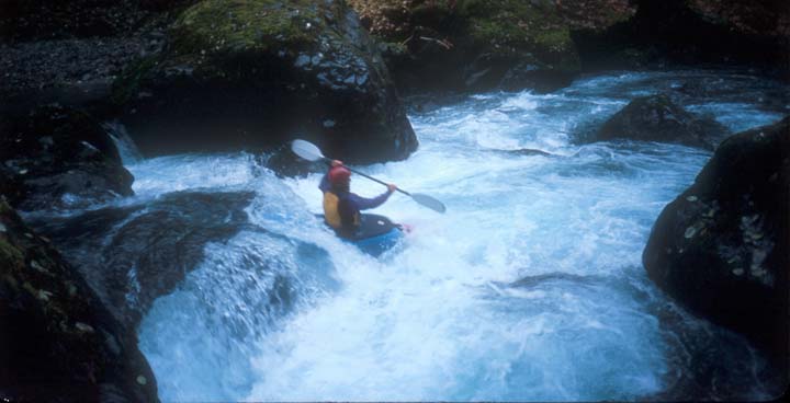
Josh in The Maze. Guess what happened next?
Josh boofs a fun ledge.
You can portage and/or pull out on either the left or right during any point of this 500-yard long rapid. We scouted most of the drops from the left side. The run was going perfect and we were staying in total control. We ran into no problems and just had fun taking photos. At one point I even hiked back up dragging my boat over rocks and through the current so Ben could get another photo. He missed the first time because he forgot to turn the camera on. This drop was through a tight slot into a nice pool. I endered for the photo. The Maze by itself was well worth the drive.

Josh intendos near the bottom of The Maze.
After The Maze things slowed down. During these times the scenery kept us content. The forest was overrun with mosses and ferns, large cedar trees and furs. This river had a totally different feel than any we had run before. It was almost embarrassing to be on a river this low. The upper sections were great but the lower section was turning out to be a pain and way too low. I would love to run it at 500cfs or more though.
During the five-mile section that followed The Maze there were plenty of Class III and a couple Class IV. The Class IV came near the end and although they were short, they would be exciting at higher flows. As it was for us they were just bony drops that involved avoiding rocks rather than holes. The last drop was in a very cool canyon. At the end of this drop we slipped between some large boulders and there was the Six-Mile Bridge.

Josh on a fun rapid near the end.
Now if we wanted to save some boat bottom for other rivers we told ourselves that we should get out here. We had already scraped a decent amount off during the last five miles. I had seen some cars on the way down and thought we could hitch a ride with little trouble. I told Ben this and so we decided to get out. There was only one problem. How do we get to the road? Before us was a decent size cliff. We must have looked very indecisive because a homeowner yelled down to us.
"Are you looking for a way out."
"Yes" I said. The way up to the bridge did not look very pleasing.
"Go down the river a hundred yards and there will be a take-out on the right." Indeed there was.
We had some trouble finding the take-out and almost decided to continue on the last six miles of bony creek. I do not think I could have handled another six miles of pushing a scraping my way downstream for at least two more hours. I got out at what looked like a clear spot even though it was a long way from the bridge. It turned out to be the end of an overgrown road. We got out and carried our boats about a quarter mile to the Dosewallips road.
The day was no longer just overcast. By this time it was raining hard. We saw no cars at first but at last a local pulled over and gave Ben a ride to his truck. In about a half an hour he was back. We packed up the kayaks, picked up the road bike, and headed back home with mixed feelings. This was definitely a fun run toward the beginning and very scenic, but we had wished the flow was much higher. Well I guess you win some and you lose some. It was still well worth the trip and a lot better than sitting home.